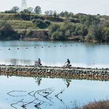
  Biking Around Lake Oroville While the spring and summer months may seem ideal for outdoor activities, winter remains a prime period for mountain biking throughout the Oroville area. Bikers not only enjoy cooler weather, but the dirt on recreation trails gets compacted by rainfall, offering increased traction following a few days of dry weather. With more than 70 miles of biking-designated trails throughout the Lake Oroville Recreation and Oroville Wildlife Areas, cyclists have a variety of trails and experiences to choose from. The Brad Freeman Trail loops throughout both recreation areas offering a 41-mile trek from the Oroville Dam Spillway area, past the Thermalito Diversion Pool, around the Thermalito Forebay and Afterbay, and through the remote Oroville Wildlife Area. Along the west side of Lake Oroville, the Potter’s Ravine system is a 15-mile trail with intermittent views of Lake Oroville. Cyclists can also bike another 8 miles from Potter’s Ravine along the North Fork Trail to the Bloomer Cove area showcasing the north fork arm of Lake Oroville. Those seeking a shorter trip may also bike from the Lake Oroville Visitor Center down to the Bidwell Canyon Saddle Dam, offering spectacular views of Lake Oroville during the ride. 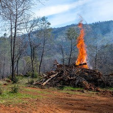 VEGETATION MANAGEMENT ACTIVITIES The Department of Water Resources (DWR) and CAL FIRE crews are resuming hand cutting, heavy equipment, and pile burning activities following the holiday season. Crews will be working in several areas throughout the Oroville Recreation Area – Loafer Creek along Highway 162 (Oro Quincy Highway) and around the Loafer Creek Campground, near Hyatt Powerplant along Oroville Dam Blvd. East, at the Lake Oroville Visitor Center, and throughout Bidwell Canyon. Work schedules are subject to change depending on weather, crew, and equipment availability. Work may cause intermittent trail closures within project areas. Recreational trail users should be cautious when entering work areas and obey all posted trail signage. Smoke from pile burning activities will be visible in the Oroville area. DWR’s Fuel Load Management Plan works to reduce wildfire risk, increase public safety, and enhance forest health around the Lake Oroville area. Ongoing vegetation management of this critical area remains a high priority for DWR and its partners at CAL FIRE, Butte County Fire Department, Butte County Sheriff’s Office, California Conservation Corps (CCC), California Department of Parks and Recreation (State Parks), and the Butte County Fire Safe Council. 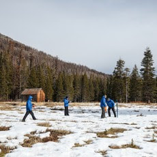 SNOW SURVEY DWR conducted the first snow survey of the season at Phillips Station on Jan. 2. The manual survey recorded 7.5 inches of snow depth and a snow water equivalent of 3 inches, which is 30 percent of average for this location. The snow water equivalent measures the amount of water contained in the snowpack and is a key component of DWR’s water supply forecast. Statewide the snowpack is 25 percent of average for this date. After one of the largest snowpacks on record last season, the start of this water year has been dry despite some recent storms in the last weeks of December that provided a small boost in the snowpack. While state reservoirs are still above average for this time of year and strong El Niño conditions are present in the Pacific Ocean, the outlook for the rest of the winter remains highly uncertain. More information about the first snow survey can be found in DWR’s press release. 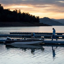 OROVILLE RECREATION
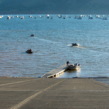
DWR, State Parks, and the California Department of Fish and Wildlife (CDFW) maintain over 92 miles of trails in the Oroville area. An interactive map of recreation facilities, including open trails and their permitted uses (hike, bike, horse, multi), is available on DWR’s Lake Oroville Recreation webpage. A paper trail map is available at various locations, including most entrance kiosks and the Lake Oroville Visitor Center. The marinas at Bidwell Canyon and Lime Saddle are open daily and provide a variety of services including a convenience store, gas, and boat rentals. The Lake Oroville Visitor Center is open daily from 9 a.m. to 5 p.m. Staffed by knowledgeable guides, the Visitor Center features interpretive displays on Oroville Dam, area geology, wildlife and habitat, hydroelectric power, and cultural and historical artifacts. View videos in the theater about the construction of Oroville Dam, walk or hike along nearby trails, and visit the 47-foot-tall observation tower that provides unsurpassed panoramic views of surrounding areas. Free guided tours for school and community groups are available by reservation. Parking and admission to the Visitor Center are free. Upstream migrating fish totals between Sept. 11 and Dec. 26 are:
CURRENT LAKE OPERATIONS Lake Oroville is at 820 feet elevation and storage is approximately 2.42 million acre-feet (MAF), which is 69 percent of its total capacity and 129 percent of the historical average. Feather River flows remain at 650 cubic feet per second (cfs) through the City of Oroville with 1,100 cfs being released from the Thermalito Afterbay River Outlet (Outlet) for a total Feather River release of 1,750 cfs downstream. DWR continues to assess releases to the Feather River daily. With rising water levels from recent storms, water may be seen on the main spillway outlet as the seals on the eight radial gates are not designed to be watertight. The gate seals do not play a role in the structural integrity of the gates, which continue to operate as intended. DWR periodically maintains and adjusts the seals during low-reservoir conditions to improve their sealing capability. Visitors to Oroville Dam may also notice minor amounts of water flowing from drains built into the emergency spillway, which is normal and expected with the emergency spillway design. The dam and emergency spillway continue to operate as intended. The public can track precipitation, snow, reservoir levels, and more at the California Data Exchange Center. The Lake Oroville gage station is identified as “ORO.” All data as of midnight 1/4/2024. 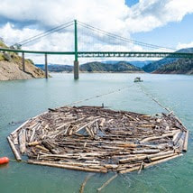 A Year in Review The arrival of 2023 ushered in continued heavy rain and snowfall throughout California including in the Northern Sierra and Feather River Watershed that feed Lake Oroville. Between December 2022 and mid-January 2023, Lake Oroville experienced a 100-foot rise in elevation, marking the start of a significant turnaround in water storage at the State Water Project’s (SWP) largest facility following several years of drought. Quickly rising water levels at the beginning of the year also initiated a huge driftwood removal endeavor for DWR’s civil maintenance crews. Beginning in January, Oroville Field Division’s civil maintenance crews spent four months corralling acres of floating driftwood at Lake Oroville. Due to the large influx in debris, maintenance staff and boats were pulled from Southern and San Joaquin Field Divisions and the Sutter and Sacramento Flood yards to assist with driftwood collection. In total, civil maintenance crews collected over 5,400 cubic yards of driftwood to ensure continued infrastructure operations and the safety of the recreating public on Lake Oroville. 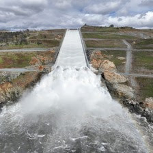 In early March, water levels brought the Loafer Point Stage I boat ramp into service for the first time since its construction in 2020. Open for water elevations above 805 feet, Loafer Point Stage I offers three boat launch lanes, a boarding dock, a lighted parking area for vehicles and boat trailers, and a restroom facility. This facility along with the adjacent lower Stage II boat ramp are a perfect complement to the Loafer Creek Recreation Area, providing access to many trails, campgrounds, a swimming beach, and the nearby Bidwell Canyon Marina and store. On March 10, rising reservoir levels and flood control manual requirements prompted DWR to release water from Oroville Dam’s main spillway for the first time since 2019. By June, melting snowpack and water runoff into Lake Oroville had filled the reservoir to 100 percent capacity. Over the course of the spring and summer seasons, DWR released over 2,370,000 acre-feet of water from the main spillway, approximately 67 percent of Lake Oroville’s capacity. Construction continued on the River Valve Outlet System (RVOS) at Oroville Dam. The system is a series of two parallel outlet conduits, each with two valves, that have the capacity to draw water from deep in Lake Oroville for release. The RVOS is a critical feature of the dam, providing the ability to discharge cold water to support Feather River temperatures necessary for fish health. It also ensures the ability to maintain Feather River flows through RVOS releases during drought years, especially if reservoir levels drop below Hyatt Powerplant’s water intake structures. 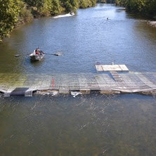 Around the end of July, DWR completed installation of a fish monitoring station in the Feather River about five miles downstream of Oroville. The fish monitoring structure guides fish past an underwater video camera, allowing biologists to review footage and determine abundance, run timing, and origin (hatchery or natural) of steelhead and Chinook salmon populations. This information will improve management of these important fish populations in the Feather River and at the Feather River Fish Hatchery. At the end of August, DWR also completed construction on a salmonid habitat improvement project in the Feather River near the Feather River Fish Hatchery and Bedrock Park in Oroville. The project placed approximately 9,000 cubic yards of gravel at multiple locations to improve existing spawning habitat sites. Salmonid access to existing river side channels was also improved by excavating and redistributing accumulated streambed material. High levels of in-river spawning were seen this fall in project areas. Between mid-September and early December, DWR performed routine concrete and slab and wall joint sealant repair work on localized areas of Oroville Dam’s main spillway identified during annual inspections. While the main spillway continues to perform well and operate as designed, periodic concrete and sealant repairs of the spillway are expected due to seasonal temperature variations, spillway releases, and sun exposure. In addition, inspections of the 51,000 feet of piping that supports the spillway’s improved drainage system were completed this season. 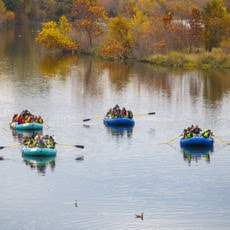 This fall, DWR partnered with Friends of Butte Creek and the Oroville Chamber of Commerce to offer educational Floating Classroom tours on the Feather River. Rafting trips floated through Feather River spawning habitat while DWR scientists provided information on Chinook salmon conservation efforts, ongoing and planned research, and restoration and monitoring projects. Profits from weekend public tours were used to provide free floating classroom experiences to 15 classes from nine local schools during the peak salmon spawning season. DWR was also awarded Hazard Mitigation Grant Program (HMGP) funds totaling $900,000 from the Federal Emergency Management Agency (FEMA) to complete a 305-acre hazardous fuels reduction project in the Lake Oroville area. This multi-year project reduces the risk of a catastrophic wildfire by improving defensible space around infrastructure, roads, and residential areas, with work performed in conjunction with Oroville Field Division’s ongoing Fuel Load Management Plan. 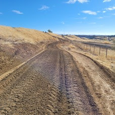 Construction work on a 1.5-mile section of the Brad Freeman Trail between Cherokee Road and the Highway 70 Garden Drive overpass began in October. Planned improvements include upgrading the existing gravel/dirt trail to include an 8-foot-wide asphalt path for cyclists and a 4-foot-wide decomposed granite path for pedestrians. Existing entrance bollards will also be replaced with wider, accessible box gates. The improvement project is supported by a Land and Water Conservation Fund grant through the National Park Service, with remaining funding for the $700,000 project provided by DWR. Project completion is expected in June 2025.
DWR and the California Department of Fish and Wildlife (CDFW) completed spawning activities this fall for spring, inland, and fall-run Chinook salmon at the Feather River Fish Hatchery in Oroville. The Hatchery collected enough eggs to meet its production goals and anticipates meeting target release numbers of 2 million spring-run, 125,000 inland Chinook destined for Lake Oroville, and 6 million fall-run, with an additional 3.5 million fall-run to be released to mitigate declines in Chinook salmon populations during recent drought years. Chinook salmon fingerlings raised at the Hatchery will later be released in the Feather River and San Francisco Bays to support inland and ocean fisheries. The Feather River Fish Hatchery is a California SWP facility owned and maintained by DWR, which funds hatchery operations. CDFW operates the hatchery, including fish spawning, rearing, and stocking activities. DWR looks forward to initiating and completing more projects in 2024 at the Oroville-Thermalito Complex. The Lake Oroville Community Update will continue to share news and information with the community. OROVILLE RECREATION The Lake Oroville Visitor Center will close at 1 p.m. Sunday, Dec. 24 and close all day for the Christmas and New Year holidays. Visitors may still access nearby trails during the holiday closures. Open seven days a week from 9 a.m. to 5 p.m., the Visitor Center features interpretive displays on Oroville Dam, area geology, wildlife and habitat, hydroelectric power, and cultural and historical artifacts. View videos in the theater about the construction of Oroville Dam, walk or hike along nearby trails, and visit the 47-foot-tall observation tower that provides unsurpassed panoramic views of surrounding areas. Free guided tours for school and community groups are available by reservation. Parking and admission to the Visitor Center are free. The Spillway Day Use Area and Boat Ramp will be open from 6 a.m. to 6 p.m. on Christmas Eve and Christmas Day. Daily winter hours for the Spillway Day Use Area are currently 6 a.m. to 8 p.m. through April 30, 2024. DWR, the California Department of Parks and Recreation, and CDFW maintain over 92 miles of trails in the Oroville area. An interactive map of recreation facilities, including open trails and their permitted uses (hike, bike, horse, multi), is available on DWR’s Lake Oroville Recreation webpage. A paper trail map is available at various locations, including most entrance kiosks and the Lake Oroville Visitor Center. The marinas at Bidwell Canyon and Lime Saddle are open daily and provide a variety of services including a convenience store, gas, and boat rentals. Upstream migrating fish totals between Sept. 11 and Dec. 13 are:
CURRENT LAKE OPERATIONS Lake Oroville is at 815 feet elevation and storage is approximately 2.37 million acre-feet (MAF), which is 67 percent of its total capacity and 130 percent of the historical average. Feather River flows remain at 650 cubic feet per second (cfs) through the City of Oroville with 1,100 cfs being released from the Thermalito Afterbay River Outlet (Outlet) for a total Feather River release of 1,750 cfs downstream. DWR continues to assess releases to the Feather River daily. With rising water levels from recent storms, water may be seen on the main spillway outlet as the seals on the eight radial gates are not designed to be watertight. The gate seals do not play a role in the structural integrity of the gates, which continue to operate as intended. DWR periodically maintains and adjusts the seals during low-reservoir conditions to improve their sealing capability. Visitors to Oroville Dam may also notice minor amounts of water flowing from drains built into the emergency spillway, which is normal and expected with the emergency spillway design. The dam and emergency spillway continue to operate as intended. The public can track precipitation, snow, reservoir levels, and more at the California Data Exchange Center. The Lake Oroville gage station is identified as “ORO.” All data as of midnight 12/21/2023. DWR wishes everyone a happy holiday season. The Lake Oroville Community Update will return on January 5, 2024  Salmon Spawning Operations The Department of Water Resources (DWR) and the California Department of Fish and Wildlife (CDFW) completed spawning activities for spring, inland, and fall-run Chinook salmon at the Feather River Fish Hatchery in Oroville. The Hatchery collected enough eggs to meet its production goals and anticipates meeting target release numbers of 2 million spring-run, 125,000 inland Chinook destined for Lake Oroville, and 6 million fall-run, with an additional 3.5 million fall-run to be released to mitigate declines in Chinook salmon populations during recent drought years. Chinook salmon fingerlings raised at the Hatchery will later be released in the Feather River and San Francisco Bays to support inland and ocean fisheries. In addition, DWR and CDFW continued thiamine treatment to combat B1 vitamin deficiencies. This treatment improves the health of the fish, increasing the survival of Chinook salmon from egg to juvenile. Thanks to a recently completed spawning gravel improvement project in the Feather River, combined with the substantial number of salmon that returned to the Feather River this fall, high levels of in-river spawning have been seen over the last few months. DWR’s newly installed Feather River Fish Monitoring Station counted upstream migrating fish totals of 31,003 Chinook salmon and 787 steelhead between Sept. 11 and Dec. 6. The monitoring totals help improve management of these important fish populations in the Feather River and at the Feather River Fish Hatchery. 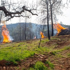 VEGETATION MANAGEMENT ACTIVITIES DWR and CAL FIRE’s Magalia Fire Center began vegetation cutting, piling, and burning activities last week near the Hyatt Powerplant along Oro Dam Blvd. East. Crews will be onsite Tuesday through Thursday each week, with vegetation management activities continuing for several months. In addition, fuel reduction activities are continuing in the Loafer Creek Recreation Area along Highway 162 (Oro Quincy Highway) with work also beginning soon in the Bidwell Canyon and Kelly Ridge areas. Work schedules are subject to change depending on weather, crew, and equipment availability. Work may cause intermittent trail closures within project areas. Recreational trail users should be cautious when entering work areas and obey all posted trail signage. Smoke from pile burning activities will be visible in the Oroville area. DWR’s Fuel Load Management Plan works to reduce wildfire risk, increase public safety, and enhance forest health around the Lake Oroville area. Ongoing vegetation management of this critical area remains a high priority for DWR and its partners at CAL FIRE, Butte County Fire Department, Butte County Sheriff’s Office, California Conservation Corps (CCC), California Department of Parks and Recreation (State Parks), and the Butte County Fire Safe Council. 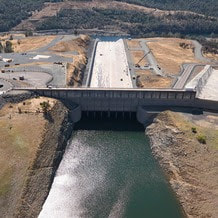 MAINTENANCE WORK ON MAIN SPILLWAY COMPLETE FOR THE SEASON DWR has completed routine maintenance work on Oroville Dam’s main spillway for the 2023 season. Work this year included routine concrete repair, complete sealant replacement on concrete slabs and wall joints, and a complete inspection of the 51,000 feet of piping that supports the spillway’s improved drainage system. Oroville Dam’s main spillway performed well and operated as designed in 2023, passing over 2,370,000 acre-feet of water – approximately 67 percent of the capacity of Lake Oroville. Due to seasonal temperature variations, spillway releases, and sun exposure, periodic concrete and joint sealant repairs of the main spillway are expected. The spillway was rebuilt to the highest engineering and safety standards with oversight and guidance by the Federal Energy Regulatory Commission (FERC), Division of Safety of Dams (DSOD), and an independent board of consultants. DWR performed a significant amount of inspection and testing throughout construction to verify compliance with project specifications. DWR also provides regular updates to the Oroville Dam Citizens Advisory Commission, a public forum for discussing operations, maintenance, and public safety activities at Oroville Dam and its facilities. 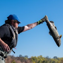 SALMON SURVEYS DWR scientists are performing weekly surveys in the Feather River through Dec. 22 to record the number of Chinook salmon returning to spawn this season. Approximately two to three boats will be on the river during weekdays conducting surveys. The weekday survey schedule is as follows, but is subject to change due to crew availability and the number of fish encountered:
 OROVILLE RECREATION
DWR, State Parks, and CDFW maintain over 92 miles of trails in the Oroville area. An interactive map of recreation facilities, including open trails and their permitted uses (hike, bike, horse, multi), is available on DWR’s Lake Oroville Recreation webpage. A paper trail map is available at various locations, including most entrance kiosks and the Lake Oroville Visitor Center. The marinas at Bidwell Canyon and Lime Saddle are open daily and provide a variety of services including a convenience store, gas, and boat rentals. The Lake Oroville Visitor Center is open seven days a week from 9 a.m. to 5 p.m. Staffed by knowledgeable guides, the Visitor Center features interpretive displays on Oroville Dam, area geology, wildlife and habitat, hydroelectric power, and cultural and historical artifacts. View videos in the theater about the construction of Oroville Dam, walk or hike along nearby trails, and visit the 47-foot-tall observation tower that provides unsurpassed panoramic views of surrounding areas. Free guided tours for school and community groups are available by reservation. Parking and admission to the Visitor Center are free. CURRENT LAKE OPERATIONS Lake Oroville is at 812 feet elevation and storage is approximately 2.32 million acre-feet (MAF), which is 66 percent of its total capacity and 129 percent of the historical average. Feather River flows remain at 650 cubic feet per second (cfs) through the City of Oroville with 1,100 cfs being released from the Thermalito Afterbay River Outlet (Outlet) for a total Feather River release of 1,750 cfs downstream. DWR continues to assess releases to the Feather River daily. Visitors to Oroville Dam may also notice minor amounts of water flowing from drains built into the emergency spillway, which is normal and expected with the emergency spillway design. The dam and emergency spillway continue to operate as intended. The public can track precipitation, snow, reservoir levels, and more at the California Data Exchange Center. The Lake Oroville gage station is identified as “ORO.” All data as of midnight 12/14/2023 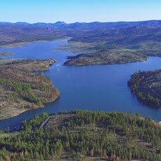 DWR Announces Initial State Water Project Allocations The Department of Water Resources (DWR) announced on Dec. 1 an initial State Water Project (SWP) allocation forecast of 10 percent of requested supplies for 2024. The SWP provides water to 29 public water agencies that serve 27 million Californians. The initial water supply forecast is the first allocation of the new water year, which began Oct. 1, and is based on current reservoir storage and an assumption of very dry conditions. So far in October and November, storms have not brought as much rain and snow. The allocation has no bearing on current water supplies or water captured in 2023. Most reservoirs in the state remain above average for this time of year following last water year’s wet winter. More information on the initial SWP allocation announcement may be found in DWR’s press release.  MAINTENANCE WORK ON MAIN SPILLWAY COMPLETE FOR THE SEASON DWR has completed routine maintenance work on Oroville Dam’s main spillway for the 2023 season. Work this year included routine concrete repair, complete sealant replacement on concrete slabs and wall joints, and a complete inspection of the 51,000 feet of piping that supports the spillway’s improved drainage system. Oroville Dam’s main spillway performed well and operated as designed in 2023, passing over 2,370,000 acre-feet of water – approximately 67 percent of the capacity of Lake Oroville. Due to seasonal temperature variations, spillway releases, and sun exposure, periodic concrete and joint sealant repairs of the main spillway are expected. The spillway was rebuilt to the highest engineering and safety standards with oversight and guidance by the Federal Energy Regulatory Commission (FERC), Division of Safety of Dams (DSOD), and an independent board of consultants. DWR performed a significant amount of inspection and testing throughout construction to verify compliance with project specifications. DWR also provides regular updates to the Oroville Dam Citizens Advisory Commission, a public forum for discussing operations, maintenance, and public safety activities at Oroville Dam and its facilities. OROVILLE PARADE OF LIGHTS Don’t miss Oroville’s annual Parade of Lights event this Saturday, Dec. 9, starting at 6 p.m. in downtown Oroville. This family-friendly event features a beautiful array of decorated floats with dancers, performers, and a marching band continuing the festive entertainment throughout the route. This year’s parade theme is “Christmas Throughout the Year: A Holiday Extravaganza” with floats representing each month of the year. Parade of Lights is organized by the Oroville Chamber of Commerce with event resource support provided by DWR. For more information about the Parade of Lights event, visit visitoroville.com. 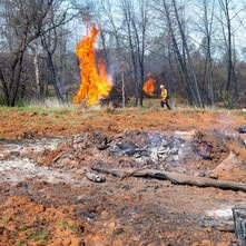 VEGETATION MANAGEMENT ACTIVITIES DWR and CAL FIRE’s Magalia Fire Center began vegetation cutting, piling, and burning activities this week near the Hyatt Powerplant along Oro Dam Blvd. East. Crews will be onsite Tuesday through Thursday each week, with vegetation management activities continuing for several months. In addition, fuel reduction activities are continuing in the Loafer Creek Recreation Area along Highway 162 (Oro Quincy Highway) for the next couple of weeks. Work schedules are subject to change depending on weather, crew, and equipment availability. Work may cause intermittent trail closures within project areas. Recreational trail users should be cautious when entering work areas and obey all posted trail signage. Smoke from pile burning activities will be visible in the Oroville area. DWR’s Fuel Load Management Plan works to reduce wildfire risk, increase public safety, and enhance forest health around the Lake Oroville area. Ongoing vegetation management of this critical area remains a high priority for DWR and its partners at CAL FIRE, Butte County Fire Department, Butte County Sheriff’s Office, California Conservation Corps (CCC), California Department of Parks and Recreation (State Parks), and the Butte County Fire Safe Council.  SALMON SURVEYS DWR scientists are performing weekly surveys in the Feather River through Dec. 22 to record the number of Chinook salmon returning to spawn this season. Approximately two to three boats will be on the river during weekdays conducting surveys. The weekday survey schedule is as follows, but is subject to change due to crew availability and the number of fish encountered:
 OROVILLE RECREATION The Lake Oroville Visitor Center will be temporarily closed Friday, Dec. 15 between 7 a.m. and noon for DWR staff training. Visitors may still access nearby trails and outside facilities during the temporary closure. Open seven days a week from 9 a.m. to 5 p.m., the Visitor Center features interpretive displays on Oroville Dam, area geology, wildlife and habitat, hydroelectric power, and cultural and historical artifacts. View videos in the theater about the construction of Oroville Dam, walk or hike along nearby trails, and visit the 47-foot-tall observation tower that provides unsurpassed panoramic views of surrounding areas. Free guided tours for school and community groups are available by reservation. Parking and admission to the Visitor Center are free.
DWR biologists are using the Feather River Fish Monitoring Station to determine abundance, run timing, and origin (hatchery or natural) of steelhead and Chinook salmon populations. This information will improve the management of these important fish populations. Upstream migrating fish totals between Sept. 11 and Dec. 2 are:
DWR, State Parks, and the Department of Fish and Wildlife maintain over 92 miles of trails in the Oroville area. An interactive map of recreation facilities, including open trails and their permitted uses (hike, bike, horse, multi), is available on DWR’s Lake Oroville Recreation webpage. A paper trail map is available at various locations, including most entrance kiosks and the Lake Oroville Visitor Center. The marinas at Bidwell Canyon and Lime Saddle are open daily and provide a variety of services including a convenience store, gas, and boat rentals. CURRENT LAKE OPERATIONS Lake Oroville is at 812 feet elevation and storage is approximately 2.33 million acre-feet (MAF), which is 66 percent of its total capacity and 131 percent of the historical average. Feather River flows remain at 650 cubic feet per second (cfs) through the City of Oroville with 1,100 cfs being released from the Thermalito Afterbay River Outlet (Outlet) for a total Feather River release of 1,750 cfs downstream. DWR continues to assess releases to the Feather River daily. Visitors to Oroville Dam may also notice minor amounts of water flowing from drains built into the emergency spillway, which is normal and expected with the emergency spillway design. The dam and emergency spillway continue to operate as intended. The public can track precipitation, snow, reservoir levels, and more at the California Data Exchange Center. The Lake Oroville gage station is identified as “ORO.” All data as of midnight 12/7/2023.  Salmon Carcass Surveys Department of Water Resources (DWR) scientists will perform weekly fish carcass surveys in the Feather River through Dec. 22 to record the number of Chinook salmon returning to spawn this season. Approximately two to three boats will be on the river during weekdays conducting carcass surveys. The weekday carcass survey schedule is as follows, but is subject to change due to crew availability and the number of fish carcasses encountered:
 STEELHEAD SPAWNING The fish ladder at the Feather River Fish Hatchery reopened Nov. 30 with steelhead spawning operations beginning around mid-December. Steelhead enter the hatchery via the fish ladder that leads up from the Feather River Fish Barrier Dam and can be seen at the viewing windows and facility. Once the spawned fish eggs have hatched, the juvenile fish will be reared at the hatchery for a full year and then released next winter into the Feather River. If there are any surplus fish beyond the production goal, fish may be planted into the Thermalito Afterbay for recreational fishing. Like the juvenile salmon that populate the Feather River, steelhead trout migrate from freshwater to marine (ocean), returning to freshwater environments to spawn. Unlike salmon, they can spawn several times during their lifetime and can live up to eight years. The “steelhead” name comes from their appearance, a more streamlined shape than Chinook salmon with a silvery or brassy color as an adult. The Feather River Fish Hatchery’s spawning operations enable Chinook salmon and steelhead to be released yearly to support Northern California and Pacific Ocean fisheries. DWR owns and maintains the facility and provides funding to the Department of Fish and Wildlife (DFW) for its spawning, rearing, and stocking operations.  MAINTENANCE WORK ON MAIN SPILLWAY NEARING COMPLETION DWR is nearing completion of routine maintenance work on Oroville Dam’s main spillway for the season. Surface concrete work on localized areas of the spillway has been extended through Dec. 8 due to favorable weather conditions. Oroville Dam’s main spillway performed well and operated as designed in 2023, passing over 2,370,000 acre-feet of water – approximately 67 percent of the capacity of Lake Oroville. Due to seasonal temperature variations, spillway releases, and sun exposure, periodic concrete and joint sealant repairs of the main spillway are expected. Work this year included routine concrete repair, complete sealant replacement on concrete slabs and wall joints, and complete inspection of the 51,000 feet of piping that support the spillway’s improved drainage system. The spillway was rebuilt to the highest engineering and safety standards with oversight and guidance by the Federal Energy Regulatory Commission (FERC), Division of Safety of Dams (DSOD), and an independent board of consultants. DWR performed a significant amount of inspection and testing throughout construction to verify compliance with project specifications. DWR also provides regular updates to the Oroville Dam Citizens Advisory Commission, a public forum for discussing operations, maintenance, and public safety activities at Oroville Dam and its facilities.  OROVILLE RECREATION
DWR biologists are using the Feather River Fish Monitoring Station to determine abundance, run timing, and origin (hatchery or natural) of steelhead and Chinook salmon populations. This information will improve the management of these important fish populations. Upstream migrating fish totals between Sept. 11 and Nov. 25 are:
The Lake Oroville Visitor Center is open seven days a week from 9 a.m. to 5 p.m. Staffed by knowledgeable guides, the Visitor Center features interpretive displays on Oroville Dam, area geology, wildlife and habitat, hydroelectric power, and cultural and historical artifacts. View videos in the theater about the construction of Oroville Dam, walk or hike along nearby trails, and visit the 47-foot-tall observation tower that provides unsurpassed panoramic views of surrounding areas. Free guided tours for school and community groups are available by reservation. Parking and admission to the Visitor Center are free. DWR, State Parks, and the Department of Fish and Wildlife maintain over 92 miles of trails in the Oroville area. An interactive map of recreation facilities, including open trails and their permitted uses (hike, bike, horse, multi), is available on DWR’s Lake Oroville Recreation webpage. A paper trail map is available at various locations, including most entrance kiosks and the Lake Oroville Visitor Center. The marinas at Bidwell Canyon and Lime Saddle are open daily and provide a variety of services including a convenience store, gas, and boat rentals. CURRENT LAKE OPERATIONS Lake Oroville is at 812 feet elevation and storage is approximately 2.33 million acre-feet (MAF), which is 66 percent of its total capacity and 133 percent of the historical average. Feather River flows remain at 650 cubic feet per second (cfs) through the City of Oroville with 1,100 cfs being released from the Thermalito Afterbay River Outlet (Outlet) for a total Feather River release of 1,750 cfs downstream. DWR continues to assess releases to the Feather River daily. Visitors to Oroville Dam may also notice minor amounts of water flowing from drains built into the emergency spillway, which is normal and expected with the emergency spillway design. The dam and emergency spillway continue to operate as intended. The public can track precipitation, snow, reservoir levels, and more at the California Data Exchange Center. The Lake Oroville gage station is identified as “ORO.” All data as of midnight 11/30/2023.  Oroville Dam Citizens Advisory Commission The California Natural Resources Agency hosted a virtual Oroville Dam Citizens Advisory Commission meeting on Nov. 15 via Zoom. In addition to public comment, the Commission received briefings on Forecast Informed Reservoir Operations, the U.S. Army Corps of Engineers’ process to update the Water Control Manual for Oroville operations, and preparations for 2023–24 winter operations. The Citizens Advisory Commission is a forum for questions and feedback from the communities surrounding Oroville Dam. For information on the meeting, please visit https://bit.ly/OrovilleCAC. A transcript of the meeting will be available on the webpage in the coming weeks. 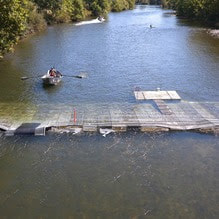 FEATHER RIVER FISH MONITORING STATION A Feather River Fish Monitoring Station installed by the Department of Water Resources (DWR) in Oroville continues to provide underwater video footage that allows biologists to determine abundance, run timing, and origin (hatchery or natural) of steelhead and Chinook salmon populations. This information helps improve management of these important fish populations in the Feather River and at the Feather River Fish Hatchery. Monitoring stations like this are widely used in many rivers to collect fish population data and provide a safer and faster method of data collection, while still permitting river recreation. Whether traveling downstream or upstream, vessels of all kinds can safely navigate over the structure. DWR’s instructional video illustrates how vessels such as powerboats, drift boats, and kayaks may navigate over the fish monitoring station. Those in more portable water vessels also have the option to use the riverbank and walk around the monitoring station. Upstream migrating fish totals between Sept. 11 and Nov. 11 are:
 MAINTENANCE WORK ON MAIN SPILLWAY EXTENDED Routine concrete and joint sealant repair work on localized areas of Oroville Dam’s main spillway has been extended to Dec. 1 due to favorable weather and lower reservoir levels. DWR will continue to monitor reservoir levels and weather forecasts closely and will end repair work for this season early if spillway releases are required for flood control. Oroville Dam’s main spillway performed well and operated as designed in 2023, passing over 2,370,000 acre-feet of water – approximately 67 percent of the capacity of Lake Oroville. Due to seasonal temperature variations, spillway releases, and sun exposure, periodic concrete and joint sealant repairs of the main spillway are expected. Work so far has included concrete repair, approximately 1,700 feet of concrete slab and wall joint sealant replacement, and inspection of the 51,000 feet of piping that support the spillway’s improved drainage system. The spillway was rebuilt to the highest engineering and safety standards with oversight and guidance by the Federal Energy Regulatory Commission (FERC), Division of Safety of Dams (DSOD), and an independent board of consultants. DWR performed a significant amount of inspection and testing throughout construction to verify compliance with project specifications. DWR also provides regular updates to the Oroville Dam Citizens Advisory Commission.  OROVILLE RECREATION
The Monument Hill Boat Ramp at the Thermalito Afterbay will be closed for repairs on Monday, Nov. 20. Trailered boat launch access to the Afterbay will still be available at the Wilbur Road boat ramp, while access for cartop boaters is available at the Larkin Road ramp. The Lake Oroville Visitor Center is open seven days a week from 9 a.m. to 5 p.m. Staffed by knowledgeable guides, the Visitor Center features interpretive displays on Oroville Dam, area geology, wildlife and habitat, hydroelectric power, and cultural and historical artifacts. View videos in the theater about the construction of Oroville Dam, walk or hike along nearby trails, and visit the 47-foot-tall observation tower that provides unsurpassed panoramic views of surrounding areas. Free guided tours for school and community groups are available by reservation. Parking and admission to the Visitor Center are free. DWR, State Parks, and the Department of Fish and Wildlife maintain over 92 miles of trails in the Oroville area. An interactive map of recreation facilities, including open trails and their permitted uses (hike, bike, horse, multi), is available on DWR’s Lake Oroville Recreation webpage. A paper trail map is available at various locations, including most entrance kiosks and the Lake Oroville Visitor Center. The marinas at Bidwell Canyon and Lime Saddle are open daily and provide a variety of services including a convenience store, gas, and boat rentals. CURRENT LAKE OPERATIONS Lake Oroville is at 814 feet elevation and storage is approximately 2.36 million acre-feet (MAF), which is 67 percent of its total capacity and 132 percent of the historical average. Feather River flows remain at 650 cubic feet per second (cfs) through the City of Oroville with 1,100 cfs being released from the Thermalito Afterbay River Outlet (Outlet) for a total Feather River release of 1,750 cfs downstream. DWR continues to assess releases to the Feather River daily. Visitors to Oroville Dam may also notice minor amounts of water flowing from drains built into the emergency spillway, which is normal and expected with the emergency spillway design. The dam and emergency spillway continue to operate as intended. The public can track precipitation, snow, reservoir levels, and more at the California Data Exchange Center. The Lake Oroville gage station is identified as “ORO.” All data as of midnight 11/16/2023. DWR wishes everyone a Happy Thanksgiving. The Lake Oroville Community Update will return on December 1, 2023.  Oroville Dam Citizens Advisory Commission The California Natural Resources Agency is hosting its 15th Oroville Dam Citizens Advisory Commission meeting on Wednesday, Nov. 15 from 10 a.m. to noon. The public meeting will be held virtually and will include presentations and public comment. The Commission will receive briefings on Forecast Informed Reservoir Operations, the U.S. Army Corps of Engineers’ process to update the Water Control Manual for Oroville operations, and preparations for 2023–24 winter operations. The Citizens Advisory Commission is a forum for questions and feedback from the communities surrounding Oroville Dam. For information on how to join the virtual meeting, please visit the Oroville Dam Citizens Advisory Commission website.  MAINTENANCE WORK ON MAIN SPILLWAY EXTENDED Routine concrete and joint sealant repair work on localized areas of Oroville Dam’s main spillway has been extended to Dec. 1 due to favorable weather and lower reservoir levels. DWR will continue to monitor reservoir levels and weather forecasts closely and will end repair work for this season early if spillway releases are required for flood control. Oroville Dam’s main spillway performed well and operated as designed in 2023, passing over 2,370,000 acre-feet of water – approximately 67 percent of the capacity of Lake Oroville. Due to seasonal temperature variations, spillway releases, and sun exposure, periodic concrete and joint sealant repairs of the main spillway are expected. Work so far has included concrete repair, approximately 1,700 feet of concrete slab and wall joint sealant replacement, and inspection of the 51,000 feet of piping that support the spillway’s improved drainage system. The spillway was rebuilt to the highest engineering and safety standards with oversight and guidance by the Federal Energy Regulatory Commission (FERC), Division of Safety of Dams (DSOD), and an independent board of consultants. DWR performed a significant amount of inspection and testing throughout construction to verify compliance with project specifications. DWR also provides regular updates to the Oroville Dam Citizens Advisory Commission, a public forum for discussing operations, maintenance, and public safety activities at Oroville Dam and its facilities.  OROVILLE WILDLIFE AREA The 11,800-acre Oroville Wildlife Area (OWA) is a forested upland and riparian habitat along the Feather River and around the Thermalito Afterbay. Managed by the California Department of Fish and Wildlife, in partnership with DWR, the OWA allows for additional outdoor recreation activities such as hunting, river- and pond-oriented fishing and boating, and wildlife observation and photography. Several trails cross throughout the OWA, providing opportunities for hiking and biking. Other trails within the OWA are not officially designated and none are ADA accessible. The Feather River runs through the center of the OWA and several locations provide unpaved boat ramp access. Both car-top and trailer launching occur at many of these ramps. A restroom is available at the day use/camping area adjacent to the Thermalito Afterbay River Outlet area. The OWA is a “Type C” wildlife area (hunting pass not required) and is open for hunting seven days a week with entry hours limited from 1.5 hours before sunrise to one hour after sunset. No rifles or pistols may be used or possessed on the wildlife area except at the designated shooting range (Rabe Rd. Shooting Range off Larkin Rd.; open seven days a week from sunrise to sunset). Lead ammunition cannot be used while hunting in California. 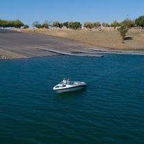 OROVILLE RECREATION
DWR biologists are using the Feather River Fish Monitoring Station to determine abundance, run timing, and origin (hatchery or natural) of steelhead and Chinook salmon populations. This information will improve the management of these important fish populations. Upstream migrating fish totals between Sept. 11 and Oct. 28 are:
The Lake Oroville Visitor Center is open seven days a week from 9 a.m. to 5 p.m. Staffed by knowledgeable guides, the Visitor Center features interpretive displays on Oroville Dam, area geology, wildlife and habitat, hydroelectric power, and cultural and historical artifacts. View videos in the theater about the construction of Oroville Dam, walk or hike along nearby trails, and visit the 47-foot-tall observation tower that provides unsurpassed panoramic views of surrounding areas. Free guided tours for school and community groups are available by reservation. Parking and admission to the Visitor Center are free. CURRENT LAKE OPERATIONS Lake Oroville is at 817 feet elevation and storage is approximately 2.39 million acre-feet (MAF), which is 68 percent of its total capacity and 133 percent of the historical average. Feather River flows remain at 650 cubic feet per second (cfs) through the City of Oroville with 1,100 cfs being released from the Thermalito Afterbay River Outlet (Outlet) for a total Feather River release of 1,750 cfs downstream. DWR continues to assess releases to the Feather River daily. Visitors to Oroville Dam may also notice minor amounts of water flowing from drains built into the emergency spillway, which is normal and expected with the emergency spillway design. The dam and emergency spillway continue to operate as intended. The public can track precipitation, snow, reservoir levels, and more at the California Data Exchange Center. The Lake Oroville gage station is identified as “ORO.” All data as of midnight 11/8/2023.  Oroville Recreation Advisory Committee The Oroville Recreation Advisory Committee (ORAC) met Nov. 3 at the Southside Oroville Community Center. ORAC was established by the Federal Energy Regulatory Commission (FERC) to review and provide recreation plan recommendations for Oroville Facilities owned by the Department of Water Resources (DWR). The 13-member committee is made up of representatives from state and local government, recreation groups, and business and community organizations. To obtain a summary of the meeting, send a request to oroville@water.ca.gov.  OROVILLE WILDLIFE AREA The 11,800-acre Oroville Wildlife Area (OWA) is a forested upland and riparian habitat along the Feather River and around the Thermalito Afterbay. Managed by the California Department of Fish and Wildlife, in partnership with DWR, the OWA allows for additional outdoor recreation activities such as hunting, river- and pond-oriented fishing and boating, and wildlife observation and photography. Several trails cross throughout the OWA, providing opportunities for hiking and biking. Other trails within the OWA are not officially designated and none are ADA accessible. The Feather River runs through the center of the OWA and has several channels with unpaved boat ramp access. Both car-top and trailer launching occur at many of these ramps. In addition, the Thermalito Afterbay River Outlet boat ramp is located within the OWA boundary and contains gravel and a concrete block mat. A restroom is available at the adjacent day use/camping area. The OWA is a “Type C” wildlife area (hunting pass not required) and is open for hunting seven days a week with entry hours limited from 1.5 hours before sunrise to one hour after sunset. No rifles or pistols may be used or possessed on the wildlife area except at the designated shooting range (Rabe Rd. Shooting Range off Larkin Rd.; open seven days a week from sunrise to sunset). Lead ammunition cannot be used while hunting in California.  VEGETATION MANAGEMENT ACTIVITIES DWR has been awarded Hazard Mitigation Grant Program (HMGP) funds totaling $900,000 from the Federal Emergency Management Agency (FEMA) to complete a 305-acre hazardous fuels reduction project in the Lake Oroville area. Fuel reduction locations include DWR property along Oro Dam Blvd. East, the Bidwell Canyon/Kelly Ridge area, and the Loafer Creek State Recreation Area. This multi-year project will reduce hazardous fuels by thinning vegetation using hand and mechanical methods accompanied by chipping. This project reduces the risk of a catastrophic wildfire by improving defensible space around infrastructure, roads, and residential areas. By proactively reducing ground fuels, thinning overgrown vegetation, and removing dead and dying vegetation, firefighters have a better chance at suppressing wildfires. HMGP work began last week and will continue over the next three years. This work may cause intermittent trail closures within project areas. Recreational trail users should be cautious when entering work areas and obey all posted trail signage. In addition to HMGP activities, DWR and CAL FIRE have resumed vegetation management activities in the Loafer Creek Recreation Area. CAL FIRE hand crews and heavy equipment operators are currently performing prescribed burns throughout Loafer Creek and along HWY 162 (Oro Quincy Highway). Smoke from pile burning activities will be visible in the Oroville area for the next several months. DWR’s Fuel Load Management Plan works to reduce wildfire risk, increase public safety, and enhance forest health around the Lake Oroville area. Ongoing vegetation management of this critical area remains a high priority for DWR and its partners at CAL FIRE, Butte County Fire Department, Butte County Sheriff’s Office, California Conservation Corps (CCC), California Department of Parks and Recreation (State Parks), and the Butte County Fire Safe Council. 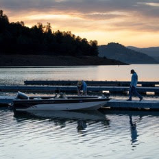 OROVILLE RECREATION
DWR biologists are using the Feather River Fish Monitoring Station to determine abundance, run timing, and origin (hatchery or natural) of steelhead and Chinook salmon populations. This information will improve the management of these important fish populations. Upstream migrating fish totals between Sept. 11 and Oct. 21 are:
The Lake Oroville Visitor Center is open seven days a week from 9 a.m. to 5 p.m. Staffed by knowledgeable guides, the Visitor Center features interpretive displays on Oroville Dam, area geology, wildlife and habitat, hydroelectric power, and cultural and historical artifacts. View videos in the theater about the construction of Oroville Dam, walk or hike along nearby trails, and visit the 47-foot-tall observation tower that provides unsurpassed panoramic views of surrounding areas. Free guided tours for school and community groups are available by reservation. Parking and admission to the Visitor Center are free. CURRENT LAKE OPERATIONS Lake Oroville is at 819 feet elevation and storage is approximately 2.42 million acre-feet (MAF), which is 68 percent of its total capacity and 134 percent of the historical average. Feather River flows remain at 650 cubic feet per second (cfs) through the City of Oroville with 1,100 cfs being released from the Thermalito Afterbay River Outlet (Outlet) for a total Feather River release of 1,750 cfs downstream. DWR continues to assess releases to the Feather River daily. Visitors to Oroville Dam may also notice minor amounts of water flowing from drains built into the emergency spillway, which is normal and expected with the emergency spillway design. The dam and emergency spillway continue to operate as intended. The public can track precipitation, snow, reservoir levels, and more at the California Data Exchange Center. The Lake Oroville gage station is identified as “ORO.” All data as of midnight 11/2/2023.  Oroville Recreation Advisory Committee The Oroville Recreation Advisory Committee (ORAC) will hold a public meeting on Friday, Nov. 3 at 10 a.m. at the Southside Oroville Community Center located at 2959 Lower Wyandotte Road, Oroville, CA, 95966. ORAC was established by the Federal Energy Regulatory Commission (FERC) to review and provide recreation plan recommendations for Oroville Facilities owned by the Department of Water Resources (DWR). The 13-member committee is made up of representatives from state and local government, recreation groups, and business and community organizations.  Flood Preparedness Week This week is Flood Preparedness Week, which runs from Oct. 21 to Oct. 28. More than seven million California residents are at risk of flooding, and many don’t realize it. Flooding can occur throughout the state, from rural to urban areas, in valley and desert communities, in mountain regions, and along the coast. Every California county has received a flood-related emergency declaration in the past 20 years. Flooding can also happen at any time of year and can even occur during drought years. Communities that are downslope of recent wildfires are especially prone to flash floods and debris slides, as landscapes impacted by wildfires can take up to five years to recover. In recent years, DWR, as a member of the Feather River Watershed Working Group (FRWWG), helped address wildfire impacts in the watershed surrounding Lake Oroville. Following the North Complex and Dixie Fires, the FRWWG installed erosion control measures to help prevent toxic ash and burned materials from entering the waterways that supply Lake Oroville. This included debris flow measurement, cleanup, and additional water sampling activities. To prepare for flooding, all Californians should follow three basic steps:
For information on obtaining flood insurance visit https://www.floodsmart.gov/. For information on how you can prepare your household for flood emergencies, visit https://www.ready.gov/kit.  BRAD FREEMAN TRAIL IMPROVEMENTS DWR has begun construction work to improve a 1.5-mile section of the Brad Freeman Trail between Cherokee Road and the Highway 70 Garden Drive overpass. Planned improvements include upgrading the existing gravel/dirt trail to include an 8-foot-wide asphalt path for cyclists and a 4-foot-wide decomposed granite path for pedestrians. Existing entrance bollards will also be replaced with wider, accessible box gates. The improvement project is supported by a Land and Water Conservation Fund grant through the National Park Service, with remaining funding for the $700,000 project provided by DWR. During construction, portions of the Brad Freeman Trail may be closed intermittently for paving and grading work. Trail improvements are being completed in phases and work may be suspended during the winter months depending on weather conditions. Project completion is expected by June 2025..  VEGETATION MANAGEMENT ACTIVITIES DWR has been awarded Hazard Mitigation Grant Program (HMGP) funds totaling $900,000 from the Federal Emergency Management Agency (FEMA) to complete a 305-acre hazardous fuels reduction project in the Lake Oroville area. Fuel reduction locations include DWR property along Oro Dam Blvd. East, the Bidwell Canyon/Kelly Ridge area, and the Loafer Creek State Recreation Area. This multi-year project will reduce hazardous fuels by thinning vegetation using hand and mechanical methods accompanied by chipping. This project reduces the risk of a catastrophic wildfire by improving defensible space around infrastructure, roads, and residential areas. By proactively reducing ground fuels, thinning overgrown vegetation, and removing dead and dying vegetation, firefighters have a better chance at suppressing wildfires. HMGP work began this week and will continue over the next three years. This work may cause intermittent trail closures within project areas. Recreational trail users should be cautious when entering work areas and obey all posted trail signage. In addition to HMGP activities, DWR and CAL FIRE have resumed vegetation management activities in the Loafer Creek Recreation Area. Starting the week of Oct. 30, CAL FIRE hand crews and heavy equipment operators will be performing prescribed burns throughout Loafer Creek and along HWY 162 (Oro Quincy Highway). Smoke from pile burning activities will be visible in the Oroville area for the next several months. DWR’s Fuel Load Management Plan works to reduce wildfire risk, increase public safety, and enhance forest health around the Lake Oroville area. Ongoing vegetation management of this critical area remains a high priority for DWR and its partners at CAL FIRE, Butte County Fire Department, Butte County Sheriff’s Office, California Conservation Corps (CCC), California Department of Parks and Recreation (State Parks), and the Butte County Fire Safe Council.  OROVILLE RECREATION
DWR biologists are using the Feather River Fish Monitoring Station to determine abundance, run timing, and origin (hatchery or natural) of steelhead and Chinook salmon populations. This information will improve the management of these important fish populations. Upstream migrating fish totals between Sept. 11 and Oct. 19 are:
The Lake Oroville Visitor Center is open seven days a week from 9 a.m. to 5 p.m. Staffed by knowledgeable guides, the Visitor Center features interpretive displays on Oroville Dam, area geology, wildlife and habitat, hydroelectric power, and cultural and historical artifacts. View videos in the theater about the construction of Oroville Dam, walk or hike along nearby trails, and visit the 47-foot-tall observation tower that provides unsurpassed panoramic views of surrounding areas. Free guided tours for school and community groups are available by reservation. Parking and admission to the Visitor Center are free. CURRENT LAKE OPERATIONS Lake Oroville is at 822 feet elevation and storage is approximately 2.45 million acre-feet (MAF), which is 69 percent of its total capacity and 134 percent of the historical average. Feather River flows remain at 650 cubic feet per second (cfs) through the City of Oroville with 1,800 cfs being released from the Thermalito Afterbay River Outlet (Outlet) for a total of 2,450 cfs downstream of the Outlet. Outlet releases are scheduled to be reduced starting Sunday, Oct. 29, with Outlet releases reduced to 1,100 cfs by Nov. 1 for a total flow below the Outlet of 1,750 cfs. DWR continues to assess releases to the Feather River daily. Visitors to Oroville Dam may also notice minor amounts of water flowing from drains built into the emergency spillway, which is normal and expected with the emergency spillway design. The dam and emergency spillway continue to operate as intended. The public can track precipitation, snow, reservoir levels, and more at the California Data Exchange Center. The Lake Oroville gage station is identified as “ORO.” All data as of midnight 10/26/2023  Brad Freeman Trail Improvements The Department of Water Resources (DWR) has begun construction work to improve a 1.5-mile section of the Brad Freeman Trail between Cherokee Road and the Highway 70 Garden Drive overpass. Planned improvements include upgrading the existing gravel/dirt trail to include an 8-foot-wide asphalt path for cyclists and a 4-foot-wide decomposed granite path for pedestrians. Existing entrance bollards will also be replaced with wider, accessible box gates. The improvement project is supported by a Land and Water Conservation Fund grant through the National Park Service, with remaining funding for the $700,000 project provided by DWR. During construction, portions of the Brad Freeman Trail may be closed intermittently for paving and grading work. Trail improvements are being completed in phases and work may be suspended during the winter months depending on weather conditions. Project completion is expected by June 2025.  VEGETATION MANAGEMENT ACTIVITIES DWR has been awarded Hazard Mitigation Grant Program (HMGP) funds totaling $900,000 from the Federal Emergency Management Agency (FEMA) to complete a 305-acre hazardous fuels reduction project in the Lake Oroville area. Fuel reduction locations include DWR property along Oro Dam Blvd. East, the Bidwell Canyon/Kelly Ridge area, and the Loafer Creek State Recreation Area. This multi-year project will reduce hazardous fuels by thinning vegetation using hand and mechanical methods accompanied by chipping. This project reduces the risk of a catastrophic wildfire by improving defensible space around infrastructure, roads, and residential areas. By proactively reducing ground fuels, thinning overgrown vegetation, and removing dead and dying vegetation, firefighters have a better chance at suppressing wildfires. HMGP work is anticipated to begin Oct. 23 and will continue over the next three years. This work may cause intermittent trail closures within project areas. Recreational trail users should be cautious when entering work areas and obey all posted trail signage. In addition to HMPG activities, DWR and CAL FIRE have resumed vegetation management activities in the Loafer Creek Recreation Area. CAL FIRE hand crews and heavy equipment operators will be working throughout Loafer Creek and along HWY 162 (Oro Quincy Highway) for the next several months. Smoke from pile burning activities will be visible in the Oroville area. DWR’s Fuel Load Management Plan works to reduce wildfire risk, increase public safety, and enhance forest health around the Lake Oroville area. Ongoing vegetation management of this critical area remains a high priority for DWR and its partners at CAL FIRE, Butte County Fire Department, Butte County Sheriff’s Office, California Conservation Corps (CCC), California Department of Parks and Recreation (State Parks), and the Butte County Fire Safe Council.  CALIFORNIA PREPARES FOR A POSSIBLE WET EL NIÑO YEAR DWR and its federal and local partners are preparing for the new water year, which started Oct. 1, and the possibility of another wet season under strong El Niño conditions. DWR will utilize the most advanced forecasting tools with our partners at the National Oceanic and Atmospheric Administration (NOAA), the Scripps Institution of Oceanography, and others to prepare for whatever may come to California in the months ahead. DWR and the U.S. Bureau of Reclamation, which operate the State Water Project and Central Valley Project respectively, are closely coordinating to ensure the state’s reservoirs have flood protection space available while storing as much water as possible in case drought conditions return. This past winter’s storms provided a huge boost to the State Water Project (SWP), which captured a total of 3.5 million acre-feet of water in reservoirs since Dec. 1, 2022. Lake Oroville levels recovered and had the single biggest increase in the SWP’s history last water year, gaining more than 2.5 million acre-feet of water between November 2022 and June 2023. More information about El Niño preparations can be found in DWR’s news release.  OROVILLE RECREATION
DWR biologists are using the Feather River Fish Monitoring Station to determine abundance, run timing, and origin (hatchery or natural) of steelhead and Chinook salmon populations. This information will improve the management of these important fish populations. Upstream migrating fish totals between Sept. 11 and Oct. 13 are:
The Lake Oroville Visitor Center is open seven days a week from 9 a.m. to 5 p.m. Staffed by knowledgeable guides, the Visitor Center features interpretive displays on Oroville Dam, area geology, wildlife and habitat, hydroelectric power, and cultural and historical artifacts. View videos in the theater about the construction of Oroville Dam, walk or hike along nearby trails, and visit the 47-foot-tall observation tower that provides unsurpassed panoramic views of surrounding areas. Free guided tours for school and community groups are available by reservation. Parking and admission to the Visitor Center are free. CURRENT LAKE OPERATIONS Lake Oroville is at 824 feet elevation and storage is approximately 2.48 million acre-feet (MAF), which is 70 percent of its total capacity and 134 percent of the historical average. Feather River releases are at 2,450 cubic feet per second (cfs). Flows through the City of Oroville remain at 650 cfs with releases from the Thermalito Afterbay Outlet (Outlet) at 1,800 cfs for a total of 2,450 cfs downstream of the Outlet. DWR continues to assess releases to the Feather River daily. Visitors to Oroville Dam may also notice minor amounts of water flowing from drains built into the emergency spillway, which is normal and expected with the emergency spillway design. The dam and emergency spillway continue to operate as intended. The public can track precipitation, snow, reservoir levels, and more at the California Data Exchange Center. The Lake Oroville gage station is identified as “ORO.” All data as of midnight 10/19/2023. |
Archives
May 2024
Categories
All
|
 RSS Feed