  Main Spillway Releases Continue The Department of Water Resources (DWR) continues water releases from Lake Oroville using the main spillway and Hyatt Powerplant. During the winter months, releases from Lake Oroville provide flood protection to downstream communities by maintaining storage capacity in the reservoir for additional rain capture and future snowmelt. DWR coordinates releases closely with the U.S. Army Corps of Engineers and other water operators and adjusts releases as needed to account for continuing runoff. The information below reflects current reservoir level estimates. Forecasts can change quickly and may affect the estimates provided.
Crews may also be seen working near the main spillway for several weeks. Sections of the spillway’s underdrain system are being re-inspected to capture additional video footage. In addition, crews will be performing maintenance and repairs to the spillway’s lighting system. The Lake Oroville reservoir is the largest storage facility in the State Water Project, providing flood protection while supporting environmental and water delivery needs to 27 million Californians. In 2023, Oroville Dam’s main spillway passed over 2,370,000 acre-feet of water, 67 percent of Lake Oroville’s capacity, with flows as high as 36,000 cfs. The main spillway continues to perform well and operate as designed. DWR continues to monitor lake levels, weather forecasts, and mountain snow levels to optimize water storage while allowing for carryover storage into next year.  MARCH SNOW SURVEY DWR conducted the third snow survey of the season at Phillips Station on Feb. 29. The manual survey recorded 47.5 inches of snow depth and a snow water equivalent of 18 inches, which is 77 percent of average for this location. The snow water equivalent measures the amount of water contained in the snowpack and is a key component of DWR’s water supply forecast. Today’s results reflect continued improvement in the snowpack since the slow and dry start to the water year. DWR’s electronic readings from 130 stations placed throughout the state indicate that the statewide snowpack’s snow water equivalent is 18.7 inches, or 80 percent of average for this date, an improvement from just 28 percent of average on Jan. 1. The snowpack is currently only 70 percent of the critical April 1 average, when the snowpack is typically at its peak. An incoming storm is expected to bring several feet of snow to the Sierra Nevada this weekend. More information about the March snow survey may be found in DWR’s press release.  FEATHER RIVER FISH HATCHERY STEELHEAD PLANTING The Feather River Fish Hatchery raised approximately 452,000 yearling steelhead trout around 8.5 to 9.5 inches in length for 2024 releases. Around 7,000 steelhead were released in the Thermalito Afterbay the week of Feb. 12 to support recreational fishing. In addition, 1,011 adult male steelhead were released into the Thermalito Afterbay from December to February after they had been spawned at the hatchery. Hatchery-spawned females were released back to the Feather River. Approximately 445,000 steelhead were released into the Feather River at Boyd’s Pump Boat Launch between Feb. 5 and Feb. 13 to meet mitigation requirements. Releasing the young fish further downstream improves their chances of survival. Like the salmon that populate the Feather River, steelhead trout migrate from the river to the ocean, returning to the river as adults to spawn. Unlike salmon, they can spawn several times during their lifetime. The name “steelhead” comes from their appearance, a more streamlined shape than Chinook salmon with a silvery or brassy color as an adult. The Feather River Fish Hatchery is a California State Water Project (SWP) facility built in the late 1960s to mitigate impacts on fish migration resulting from the construction of Oroville Dam. DWR owns and maintains the facility and provides funding to the California Department of Fish and Wildlife (CDFW) to perform spawning, rearing, and stocking operations. OROVILLE DAM CITIZENS ADVISORY COMMISSION The California Natural Resources Agency hosted its 16th Oroville Dam Citizens Advisory Commission meeting on March 1. In addition to public comment, the Commission received briefings on the process DWR uses to prioritize and select Oroville facility projects, the forecast of expenditures for State Water Project activities at Oroville, and State emergency preparedness coordination and the use of weather forecasting in emergency response. The Citizens Advisory Commission is a forum for questions and feedback from the communities surrounding Oroville Dam. For information on the meeting, please visit the Oroville Dam Citizens Advisory Commission website. A transcript of the meeting will be available on the webpage in the coming weeks. 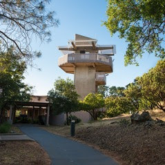 OROVILLE RECREATION
The Lake Oroville Visitor Center is open daily from 9 a.m. to 5 p.m. Staffed by knowledgeable guides, the Visitor Center features interpretive displays on Oroville Dam, area geology, wildlife and habitat, hydroelectric power, and cultural and historical artifacts. View videos in the theater about the construction of Oroville Dam, walk or hike along nearby trails, and visit the 47-foot-tall observation tower that provides unsurpassed panoramic views of surrounding areas. Free guided tours for school and community groups are available by reservation. Parking and admission to the Visitor Center are free. DWR, the California Department of Parks and Recreation (State Parks), and CDFW maintain over 92 miles of trails in the Oroville area. An interactive map of recreation facilities, including open trails and their permitted uses (hike, bike, horse, multi), is available on DWR’s Lake Oroville Recreation webpage. A paper trail map is available at various locations, including most entrance kiosks and the Lake Oroville Visitor Center. Trail users on the Brad Freeman Bike Trail that follows the old railroad grade between downtown Oroville and Hyatt Powerplant have long enjoyed the section of trail through the historic train tunnel. Unfortunately, wire theft and vandalism have rendered the train tunnel’s lighting system inoperable and beyond repair. DWR is designing an entirely new lighting system with construction anticipated in late 2024. The trail will remain open, but users are advised to bring their own light to navigate the train tunnel. Lake Oroville is one of the State Water Project’s premier recreational destinations and one of California’s best fishing spots. The lake provides both warm-water and cold-water fisheries and is a popular destination for bass tournaments. Below the Oroville Dam, the Thermalito Afterbay and the Feather River offer additional excellent fishing opportunities. The marinas at Bidwell Canyon and Lime Saddle are open daily and provide a variety of services including a convenience store, gas, and boat rentals. Upstream migrating fish totals between Jan. 1 and Feb. 25 are:
CURRENT LAKE OPERATIONS Lake Oroville is at 860 feet elevation and storage is approximately 2.95 million acre-feet (MAF), which is 83 percent of its total capacity and 132 percent of the historical average. Feather River flows remain at 3,650 cfs through the City of Oroville with 10,350 cfs being released from the Thermalito Afterbay River Outlet (Outlet) for a total Feather River release of 14,000 cfs downstream. DWR continues to assess releases to the Feather River daily. Visitors to Oroville Dam may also notice minor amounts of water flowing from drains built into the emergency spillway, which is normal and expected with the emergency spillway design. The dam and emergency spillway continue to operate as intended. The public can track precipitation, snow, reservoir levels, and more at the California Data Exchange Center. The Lake Oroville gage station is identified as “ORO.” All data as of midnight 2/29/2024. 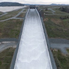 Main Spillway Releases Continue The Department of Water Resources (DWR) is continuing water releases from Lake Oroville using the main spillway and Hyatt Powerplant. During the winter months, releases from Lake Oroville provide flood protection to downstream communities by maintaining storage capacity in the reservoir for additional rain capture and future snowmelt. DWR coordinates releases closely with the U.S. Army Corps of Engineers and other water operators and adjusts releases as needed to account for continuing runoff. The information below reflects current reservoir level estimates. Forecasts can change quickly and may affect the estimates provided.
Crews may also be seen working near the main spillway for several weeks. Sections of the spillway’s underdrain system are being re-inspected to capture additional video footage. In addition, crews will be performing maintenance and repairs to the spillway’s lighting system. The Lake Oroville reservoir is the largest storage facility in the State Water Project, providing flood protection while supporting environmental and water delivery needs to 27 million Californians. In 2023, Oroville Dam’s main spillway passed over 2,370,000 acre-feet of water, 67 percent of Lake Oroville’s capacity, with flows as high as 36,000 cfs. The main spillway continues to perform well and operate as designed. DWR continues to monitor lake levels, weather forecasts, and mountain snow levels to optimize water storage while allowing for carryover storage into next year. Oroville Dam Citizens Advisory Commission The California Natural Resources Agency is hosting its 16th Oroville Dam Citizens Advisory Commission meeting Friday, March 1 from 10 a.m. to noon at the Southside Oroville Community Center located at 2959 Lower Wyandotte Road, Oroville, CA, 95966. The public meeting will include presentations and public comment. The Commission will receive briefings on the process DWR uses to prioritize and select Oroville facility projects, the forecast of expenditures for State Water Project activities at Oroville, and State emergency preparedness coordination and the use of weather forecasting in emergency response. The Citizens Advisory Commission is a forum for questions and feedback from the communities surrounding Oroville Dam. For more information about the meeting, please visit the Oroville Dam Citizens Advisory Commission website. 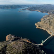 STATE WATER PROJECT ALLOCATION DWR announced on Feb. 21 an increase in the State Water Project (SWP) allocation forecast for 2024. The forecasted allocation is now 15 percent of requested supplies, up from the 10 percent initial allocation announced in December. This translates to about 200,000 acre-feet of additional water for the 29 public water agencies that serve 27 million Californians. This assessment does not include the results of any of the storms that hit California earlier this month. The State Water Project will review conditions and may revise the forecasted allocation in mid-March. The February allocation forecast update takes into account snow survey measurements and data up until Feb.1 and spring runoff forecasts outlined in the first Bulletin 120 of the season. More information about the allocation announcement is available in DWR’s press release.  OROVILLE RECREATION
DWR, the California Department of Parks and Recreation (State Parks), and the California Department of Fish and Wildlife (CDFW) maintain over 92 miles of trails in the Oroville area. An interactive map of recreation facilities, including open trails and their permitted uses (hike, bike, horse, multi), is available on DWR’s Lake Oroville Recreation webpage. A paper trail map is available at various locations, including most entrance kiosks and the Lake Oroville Visitor Center. The Lake Oroville Visitor Center is open daily from 9 a.m. to 5 p.m. Staffed by knowledgeable guides, the Visitor Center features interpretive displays on Oroville Dam, area geology, wildlife and habitat, hydroelectric power, and cultural and historical artifacts. View videos in the theater about the construction of Oroville Dam, walk or hike along nearby trails, and visit the 47-foot-tall observation tower that provides unsurpassed panoramic views of surrounding areas. Free guided tours for school and community groups are available by reservation. Parking and admission to the Visitor Center are free. Lake Oroville is one of the State Water Project’s premier recreational destinations and one of California’s best fishing spots. The lake provides both warm-water and cold-water fisheries and is a popular destination for bass tournaments. Below the Oroville Dam, the Thermalito Afterbay and the Feather River offer additional excellent fishing opportunities. The marinas at Bidwell Canyon and Lime Saddle are open daily and provide a variety of services including a convenience store, gas, and boat rentals. Upstream migrating fish totals between Jan. 1 and Feb. 18 are:
Feather River flows remain at 650 cfs through the City of Oroville with 9,350 cfs being released from the Thermalito Afterbay River Outlet (Outlet) for a total Feather River release of 10,000 cfs downstream. DWR continues to assess releases to the Feather River daily. Visitors to Oroville Dam may also notice minor amounts of water flowing from drains built into the emergency spillway, which is normal and expected with the emergency spillway design. The dam and emergency spillway continue to operate as intended. The public can track precipitation, snow, reservoir levels, and more at the California Data Exchange Center. The Lake Oroville gage station is identified as “ORO.” All data as of midnight 2/22/2024. 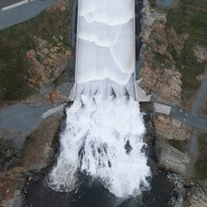 Main Spillway Releases Resume The Department of Water Resources (DWR) increased water releases from Lake Oroville this week in advance of a series of storms. Water releases from Oroville Dam’s main spillway also resumed around 10 a.m. today with continuing releases through the Hyatt Powerplant. During the winter months, releases from Lake Oroville provide flood protection to downstream communities by maintaining storage capacity in the reservoir for additional rain capture. DWR coordinates releases closely with the U.S. Army Corps of Engineers and other water operators and adjusts releases as needed to account for continuing runoff. The information below reflects current reservoir level estimates. Forecasts can change quickly and may affect the estimates provided.
Crews may also be seen working near the main spillway for several weeks. Sections of the spillway’s underdrain system are being re-inspected to capture additional video footage. In addition, crews will be performing maintenance and repairs to the spillway’s lighting system. The Lake Oroville reservoir is the largest storage facility in the State Water Project, providing flood protection while supporting environmental and water delivery needs to 27 million Californians. In 2023, Oroville Dam’s main spillway passed over 2,370,000 acre-feet of water, 67 percent of Lake Oroville’s capacity, with flows as high as 36,000 cfs. The main spillway continues to perform well and operate as designed. DWR continues to monitor lake levels, weather forecasts, and mountain snow levels to optimize water storage while allowing for carryover storage into next year. Temporary Bathroom Closure Extended DWR is alerting Oroville Dam recreation users to extended temporary closures of the Oroville Dam Overlook and Spillway Day-Use Area restrooms for sewer system work. Due to material delays, the bathrooms are expected to remain closed through the week of Feb. 18 with closures possibly extending into the following week. DWR has placed portable toilets and hand washing stations at these locations to continue to provide restroom facilities. 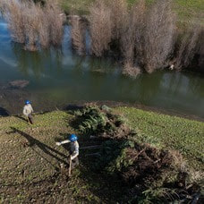 CHRISTMAS TREE HABITAT CONSTRUCTION DWR, the California Conservation Corps (CCC), and the Department of Fish and Wildlife (CDFW) finished constructing fish habitat structures at Lake Oroville and the Thermalito Afterbay using just over 1,000 recycled Christmas trees. The trees were again collected by Chico Boy Scout Troop 2 and delivered free of charge to the Oroville facilities by Recology, a local waste management company. To create the habitat structures at Lake Oroville and the Thermalito Afterbay, members of the CCC team bundle the recycled holiday trees together and anchor them in various locations around the lakebed. At Lake Oroville near the Saddle Dam Recreation Area, 625 trees were assembled into 29 structures. At the Thermalito Afterbay, 426 trees were assembled into 42 structures. Anchoring the trees allows them to remain submerged when the water levels rise, providing juvenile fish safe refuge and improving fish populations. When water levels drop the structures then provide habitat for native animals. This marks the 30th year that DWR has worked with local groups to construct fish habitat structures, making it one of the longest continuously running warmwater fish habitat improvement programs in the State of California.  OROVILLE RECREATION
The Lake Oroville Visitor Center is open daily from 9 a.m. to 5 p.m. Staffed by knowledgeable guides, the Visitor Center features interpretive displays on Oroville Dam, area geology, wildlife and habitat, hydroelectric power, and cultural and historical artifacts. View videos in the theater about the construction of Oroville Dam, walk or hike along nearby trails, and visit the 47-foot-tall observation tower that provides unsurpassed panoramic views of surrounding areas. Free guided tours for school and community groups are available by reservation. Parking and admission to the Visitor Center are free. Lake Oroville is one of the State Water Project’s premier recreational destinations and one of California’s best fishing spots. The lake provides both warm-water and cold-water fisheries and is a popular destination for bass tournaments. Below the Oroville Dam, the Thermalito Afterbay and the Feather River offer additional excellent fishing opportunities. The marinas at Bidwell Canyon and Lime Saddle are open daily and provide a variety of services including a convenience store, gas, and boat rentals. Upstream migrating fish totals between Sept. 11, 2023 and Feb. 10, 2024 are:
CURRENT LAKE OPERATIONS Lake Oroville is at 850 feet elevation and storage is approximately 2.81 million acre-feet (MAF), which is 79 percent of its total capacity and 131 percent of the historical average. Feather River flows remain at 650 cfs through the City of Oroville with 7,350 cfs being released from the Thermalito Afterbay River Outlet (Outlet) for a total Feather River release of 8,000 cfs downstream. DWR continues to assess releases to the Feather River daily. Visitors to Oroville Dam may also notice minor amounts of water flowing from drains built into the emergency spillway, which is normal and expected with the emergency spillway design. The dam and emergency spillway continue to operate as intended. The public can track precipitation, snow, reservoir levels, and more at the California Data Exchange Center. The Lake Oroville gage station is identified as “ORO.” All data as of midnight 2/15/2024.  Main Spillway Releases End The Department of Water Resources (DWR) stopped water releases from Oroville Dam’s main spillway at 10 a.m. on Feb. 7 due to low inflow into Lake Oroville. Water releases are still being made through the Hyatt Powerplant to provide flood protection to downstream communities during the winter storm season. DWR coordinates releases closely with the U.S. Army Corps of Engineers and other water operators and adjusts releases as needed to account for continuing runoff. Visitors to Oroville Dam may still see water on the main spillway even when the radial gates are closed as they are not designed to be watertight. The seals do not play a role in the structural integrity of the gates, which continue to operate as intended. DWR periodically maintains and adjusts the seals during low-reservoir conditions to improve their sealing capability. Total releases to the Feather River amount to 3,000 cubic feet per second with 650 cfs being routed down the low-flow channel through the City of Oroville. An additional 2,350 cfs is being released from the Thermalito Afterbay River Outlet, located 5 miles downstream from Oroville. Feather River releases may increase again in the future to account for additional incoming storms and high inflows. Feather River recreation users are advised to remain alert as river flows are expected to be swift and cold and may change based on projected weather forecasts. Starting this week, crews may also be seen working near the main spillway. Sections of the spillway’s underdrain system are being re-inspected to capture additional video footage. In addition, crews will be performing maintenance and repairs to the spillway’s lighting system. The Lake Oroville reservoir is the largest storage facility in the State Water Project, providing flood protection while supporting environmental and water delivery needs to 27 million Californians. In 2023, Oroville Dam’s main spillway passed over 2,370,000 acre-feet of water, 67 percent of Lake Oroville’s capacity, with flows as high as 36,000 cfs. The main spillway continues to perform well and operate as designed. DWR continues to monitor lake levels, weather forecasts, and mountain snow levels to optimize water storage while allowing for carryover storage into next year. Temporary Bathroom Closure DWR is alerting Oroville Dam recreation users to temporary closures of the Oroville Dam Overlook and Spillway Day-Use Area restrooms for sewer system work. The bathrooms will close starting Monday, Feb. 12 and are expected to remain closed for the duration of repairs, approximately one week. During the work, DWR will place portable toilets and hand washing stations at these locations to continue to provide restroom facilities.  CHRISTMAS TREE HABITAT CONSTRUCTION DWR, the California Conservation Corps (CCC), and the Department of Fish and Wildlife (CDFW) finished constructing fish habitat structures at Lake Oroville and the Thermalito Afterbay using just over 1,000 recycled Christmas trees. The trees were again collected by Chico Boy Scout Troop 2 and delivered free of charge to the Oroville facilities by Recology, a local waste management company. To create the habitat structures at Lake Oroville and the Thermalito Afterbay, members of the CCC team bundle the recycled holiday trees together and anchor them in various locations around the lakebed. At Lake Oroville near the Saddle Dam Recreation Area, 625 trees were assembled into 29 structures. At the Thermalito Afterbay, 426 trees were assembled into 42 structures. Anchoring the trees allows them to remain submerged when the water levels rise, providing juvenile fish safe refuge and improving fish populations. When water levels drop the structures then provide habitat for native animals. This marks the 30th year that DWR has worked with local groups to construct fish habitat structures, making it one of the longest continuously running warmwater fish habitat improvement programs in the State of California.  OROVILLE RECREATION
DWR, State Parks, and the California Department of Fish and Wildlife (CDFW) maintain over 92 miles of trails in the Oroville area. An interactive map of recreation facilities, including open trails and their permitted uses (hike, bike, horse, multi), is available on DWR’s Lake Oroville Recreation webpage. A paper trail map is available at various locations, including most entrance kiosks and the Lake Oroville Visitor Center. The Lake Oroville Visitor Center is open daily from 9 a.m. to 5 p.m. Staffed by knowledgeable guides, the Visitor Center features interpretive displays on Oroville Dam, area geology, wildlife and habitat, hydroelectric power, and cultural and historical artifacts. View videos in the theater about the construction of Oroville Dam, walk or hike along nearby trails, and visit the 47-foot-tall observation tower that provides unsurpassed panoramic views of surrounding areas. Free guided tours for school and community groups are available by reservation. Parking and admission to the Visitor Center are free. Lake Oroville is one of the State Water Project’s premier recreational destinations and one of California’s best fishing spots. The lake provides both warm-water and cold-water fisheries and is a popular destination for bass tournaments. Below the Oroville Dam, the Thermalito Afterbay and the Feather River offer additional excellent fishing opportunities. The marinas at Bidwell Canyon and Lime Saddle are open daily and provide a variety of services including a convenience store, gas, and boat rentals. Upstream migrating fish totals between Sept. 11, 2023 and Jan. 27, 2024 are:
CURRENT LAKE OPERATIONS Lake Oroville is at 845 feet elevation and storage is approximately 2.75 million acre-feet (MAF), which is 78 percent of its total capacity and 131 percent of the historical average. Feather River flows remain at 650 cfs through the City of Oroville with 2,350 cfs being released from the Thermalito Afterbay River Outlet (Outlet) for a total Feather River release of 3,000 cfs downstream. DWR continues to assess releases to the Feather River daily. Visitors to Oroville Dam may also notice minor amounts of water flowing from drains built into the emergency spillway, which is normal and expected with the emergency spillway design. The dam and emergency spillway continue to operate as intended. The public can track precipitation, snow, reservoir levels, and more at the California Data Exchange Center. The Lake Oroville gage station is identified as “ORO.” All data as of midnight 2/8/2024.  Spillway Releases Begin at Oroville Dam The Department of Water Resources (DWR) began releasing water from Oroville Dam’s main spillway on Jan. 31. Ongoing releases to the Feather River ensure storage space remains in Lake Oroville for flood control protection to downstream communities. DWR coordinates releases closely with the U.S. Army Corps of Engineers and other water operators and adjusts releases as needed to account for continuing rain. The information below reflects current reservoir level estimates. Forecasts can change quickly and may affect the estimates provided.
Starting the week of Feb. 5, crews may also be seen working near the main spillway. Sections of the spillway’s underdrain system are being re-inspected to capture additional video footage. In addition, crews will be performing maintenance and repairs to the spillway’s lighting system. The Lake Oroville reservoir is the largest storage facility in the State Water Project, providing flood protection while supporting environmental and water delivery needs to 27 million Californians. In 2023, Oroville Dam’s main spillway passed over 2,370,000 acre-feet of water, 67 percent of Lake Oroville’s capacity, with flows as high as 36,000 cfs. The main spillway continues to perform well and operate as designed. DWR continues to monitor lake levels, weather forecasts, and mountain snow levels to optimize water storage while allowing for carryover storage into next year. Oroville Recreation Advisory Committee The Oroville Recreation Advisory Committee (ORAC) met Feb. 2 at the Southside Oroville Community Center. ORAC was established by the Federal Energy Regulatory Commission (FERC) to review and provide recreation plan recommendations for Oroville Facilities owned by DWR. The 13-member committee is made up of representatives from state and local government, recreation groups, and business and community organizations. To obtain a summary of the meeting, send a request to oroville@water.ca.gov.  FEBRUARY SNOW SURVEY DWR conducted the second snow survey of the season at Phillips Station on Jan. 30. The manual survey recorded 29 inches of snow depth and a snow water equivalent of 10 inches, which is 58 percent of average for this location. The snow water equivalent measures the amount of water contained in the snowpack and is a key component of DWR’s water supply forecast. The results reflect a modest increase in the snowpack since Jan. 1, but overall conditions are still far below normal. DWR’s electronic readings from 130 stations placed throughout the state indicate that the statewide snowpack’s snow water equivalent is 8.4 inches, or 52 percent of average for this date, an improvement from just 28 percent of average on Jan. 1. One year ago, the snowpack statewide was 214 percent of average on Feb. 1. Despite additional precipitation in January, many storms so far this year have been warmer than average, producing rain rather than snow at higher elevations. Overall statewide precipitation is 82 percent of average for this date. Last year’s snowpack was aided by both above average precipitation and below average temperatures, which created a historic snowpack and improved reservoir storage statewide, which is still above average. Lake Oroville, the State Water Project’s largest reservoir, is currently 131 percent of average. More information about the recent snow survey can be found in DWR’s press release.  OROVILLE RECREATION
DWR, State Parks, and the California Department of Fish and Wildlife (CDFW) maintain over 92 miles of trails in the Oroville area. An interactive map of recreation facilities, including open trails and their permitted uses (hike, bike, horse, multi), is available on DWR’s Lake Oroville Recreation webpage. A paper trail map is available at various locations, including most entrance kiosks and the Lake Oroville Visitor Center. The Lake Oroville Visitor Center is open daily from 9 a.m. to 5 p.m. Staffed by knowledgeable guides, the Visitor Center features interpretive displays on Oroville Dam, area geology, wildlife and habitat, hydroelectric power, and cultural and historical artifacts. View videos in the theater about the construction of Oroville Dam, walk or hike along nearby trails, and visit the 47-foot-tall observation tower that provides unsurpassed panoramic views of surrounding areas. Free guided tours for school and community groups are available by reservation. Parking and admission to the Visitor Center are free. Lake Oroville is one of the State Water Project’s premier recreational destinations and one of California’s best fishing spots. The lake provides both warm-water and cold-water fisheries and is a popular destination for bass tournaments. Below the Oroville Dam, the Thermalito Afterbay and the Feather River offer additional excellent fishing opportunities. The marinas at Bidwell Canyon and Lime Saddle are open daily and provide a variety of services including a convenience store, gas, and boat rentals. Upstream migrating fish totals between Sept. 11, 2023 and Jan. 27, 2024 are:
CURRENT LAKE OPERATIONS Lake Oroville is at 842 feet elevation and storage is approximately 2.7 million acre-feet (MAF), which is 76 percent of its total capacity and 131 percent of the historical average. Feather River flows remain at 650 cfs through the City of Oroville with 9,350 cfs being released from the Thermalito Afterbay River Outlet (Outlet) for a total Feather River release of 10,000 cfs downstream. DWR continues to assess releases to the Feather River daily. Visitors to Oroville Dam may also notice minor amounts of water flowing from drains built into the emergency spillway, which is normal and expected with the emergency spillway design. The dam and emergency spillway continue to operate as intended. The public can track precipitation, snow, reservoir levels, and more at the California Data Exchange Center. The Lake Oroville gage station is identified as “ORO.” All data as of midnight 2/1/2024.  Lake Oroville Operations Update
The Department of Water Resources (DWR) began releasing water from Oroville Dam’s main spillway at 8 a.m. today. Releases to the Feather River ensure storage space remains in Lake Oroville for flood control protection. DWR coordinates releases closely with the U.S. Army Corps of Engineers and other water operators and adjusts releases as needed to account for continuing rain and snowmelt. Digital photos and b-roll from today’s spillway release are available on Pixel and Box. The information below reflects current reservoir level estimates. Forecasts can change quickly and may affect the estimates provided.
The Lake Oroville reservoir is the largest storage facility in the State Water Project, providing flood protection while supporting environmental and water delivery needs to 27 million Californians. In 2023, Oroville Dam’s main spillway passed over 2,370,000 acre-feet of water, 67 percent of Lake Oroville’s capacity, with flows as high as 36,000 cfs. The main spillway continues to perform well and operate as designed. DWR continues to monitor lake levels, weather forecasts, and mountain snow levels to optimize water storage while allowing for carryover storage into next year.  Lake Oroville Operations Update
Ahead of forecasted winter storms this week, the Department of Water Resources (DWR) began increasing water releases to the Feather River today from the Oroville-Thermalito Complex. These releases provide flood control protection for downstream communities and are coordinated closely with the U.S. Army Corps of Engineers and other water operators. Feather River recreation users are advised to remain alert as river flows are expected to be swift and cold and may change based on projected weather forecasts. The information below reflects current reservoir level estimates. Forecasts can change quickly and may affect the estimates provided.
Oroville Recreation Advisory Committee The Oroville Recreation Advisory Committee (ORAC) will hold a meeting on Friday, Feb. 2 at 10 a.m. at the Southside Oroville Community Center located at 2959 Lower Wyandotte Road, Oroville, CA, 95966. ORAC was established by the Federal Energy Regulatory Commission (FERC) to review and provide recreation plan recommendations for Oroville Facilities owned by the Department of Water Resources (DWR). The 13-member committee is made up of representatives from state and local government, recreation groups, and business and community organizations.  BROOD PONDS SUPPORT NATIVE WILDLIFE Within the Oroville-Thermalito Complex, DWR maintains several areas that preserve and enhance wildlife habitat. Encompassed within the Thermalito Afterbay’s 17 miles of shoreline and 4,300 surface acres of water are numerous brood ponds that provide prime habitat and breeding areas for waterfowl and giant garter snakes, a protected species. While water levels at the Afterbay may fluctuate based on agriculture and hydropower operations, DWR ensures brood pond habitats remain stable. A flap gate outlet system permits water to flow into brood pond areas, raising water levels, while preventing water from being released and maintaining a stable elevation for waterfowl nests and giant garter snakes. These measures ensure these species continue to thrive, upholding DWR’s commitment to protect, restore, and enhance the natural and human environments.  SNOW GOOSE FESTIVAL Celebrate one of the greatest migratory bird pathways in the world at the Snow Goose Festival of the Pacific Flyway happening Jan. 25 to Jan. 28. The festival hosts a variety of activities throughout the four-day event, including guided field trips to view the waterfowl, raptors and Snow Geese that migrate through the Northern Sacramento Valley during the winter months. DWR’s Lake Oroville Visitor Center Guides will host a free educational booth featuring kids’ activities between 9 a.m. and 3 p.m. on Saturday, Jan. 27 and Sunday, Jan. 28 at the Patrick Ranch Museum in Chico. Join festival attendees with visits to the Thermalito Forebay and Afterbay, and Oroville Wildlife Area offering possible sightings of rough-legged hawk, ferruginous hawk, merlin, bald eagle, golden eagle, red-tailed hawk, burrowing owl, ducks, grebes, and other deep-water birds. Check out the Snow Goose Festival website for more details about activities, an avian art exhibit, and guided field trips during the four-day event.  MIDWINTER BALD EAGLE SURVEY Environmental scientists from DWR participated in the National Midwinter Bald Eagle Survey on Jan. 5 and Jan. 8. This nationwide effort, coordinated by the U.S. Army Corps of Engineers, aims to determine bald eagle distribution and identify areas of important winter habitats. This year’s official count was 77 bald eagles for the Lake Oroville Winter Roost and 16 at the Thermalito Complex. Lake Oroville and the Sacramento Valley area provide an ideal habitat for bald eagles. Fish and waterfowl are the eagle’s main food source during this time of the year and large water bodies like Lake Oroville provide a wide variety of fish and the nearby wetlands and flooded rice fields provide an abundant supply of waterfowl for eagle foraging. The many trees and snags (tall dead trees) near water areas provide prime roosting locations for the bald eagles that migrate to and through the area during the winter months.  OROVILLE RECREATION
DWR, State Parks, and the California Department of Fish and Wildlife (CDFW) maintain over 92 miles of trails in the Oroville area. An interactive map of recreation facilities, including open trails and their permitted uses (hike, bike, horse, multi), is available on DWR’s Lake Oroville Recreation webpage. A paper trail map is available at various locations, including most entrance kiosks and the Lake Oroville Visitor Center. The Lake Oroville Visitor Center is open daily from 9 a.m. to 5 p.m. Staffed by knowledgeable guides, the Visitor Center features interpretive displays on Oroville Dam, area geology, wildlife and habitat, hydroelectric power, and cultural and historical artifacts. View videos in the theater about the construction of Oroville Dam, walk or hike along nearby trails, and visit the 47-foot-tall observation tower that provides unsurpassed panoramic views of surrounding areas. Free guided tours for school and community groups are available by reservation. Parking and admission to the Visitor Center are free. Lake Oroville is one of the State Water Project’s premier recreational destinations and one of California’s best fishing spots. The lake provides both warm-water and cold-water fisheries. Below the Oroville Dam, the Thermalito Forebay, Thermalito Afterbay and the Feather River offer additional excellent fishing opportunities. The marinas at Bidwell Canyon and Lime Saddle are open daily and provide a variety of services including a convenience store, gas, and boat rentals. Upstream migrating fish totals between Sept. 11, 2023 and Jan. 20, 2024 are:
CURRENT LAKE OPERATIONS Lake Oroville is at 838 feet elevation and storage is approximately 2.65 million acre-feet (MAF), which is 75 percent of its total capacity and 131 percent of the historical average. Feather River flows remain at 650 cubic feet per second (cfs) through the City of Oroville with 1,100 cfs being released from the Thermalito Afterbay River Outlet (Outlet) for a total Feather River release of 1,750 cfs downstream. DWR continues to assess releases to the Feather River daily. Winter storms have caused Lake Oroville’s elevation to rise above the level of the spillway’s main gates. While the gates are closed, water may still be seen on the main spillway outlet as the seals on the eight radial gates are not designed to be watertight. The seals do not play a role in the structural integrity of the gates, which continue to operate as intended. DWR periodically maintains and adjusts the seals during low-reservoir conditions to improve their sealing capability. Visitors to Oroville Dam may also notice minor amounts of water flowing from drains built into the emergency spillway, which is normal and expected with the emergency spillway design. The dam and emergency spillway continue to operate as intended. All data as of midnight 1/25/2024.  Midwinter Bald Eagle Survey Environmental scientists from the Department of Water Resources (DWR) participated in the National Midwinter Bald Eagle Survey on Jan. 5 and Jan. 8. This nationwide effort, coordinated by the U.S. Army Corps of Engineers, aims to determine bald eagle distribution and identify areas of important winter habitats. This year’s official count was 77 bald eagles for the Lake Oroville Winter Roost and 16 at the Thermalito Complex. Lake Oroville and the Sacramento Valley area provide an ideal habitat for bald eagles. Fish and waterfowl are the eagle’s main food source during this time of the year and large water bodies like Lake Oroville provide a wide variety of fish, and the nearby wetlands and flooded rice fields provide an abundant supply of waterfowl for eagle foraging. The many trees and snags (tall dead trees) near water areas provide prime roosting locations for the bald eagles that migrate to and through the area during the winter months.  SNOW GOOSE FESTIVAL Celebrate one of the greatest migratory bird pathways in the world at the Snow Goose Festival of the Pacific Flyway happening Jan. 25 to Jan. 28. The festival hosts a variety of activities throughout the four-day event, including guided field trips to view the waterfowl, raptors, and Snow Geese that migrate through the Northern Sacramento Valley during the winter months. DWR’s Lake Oroville Visitor Center Guides will host a free educational booth featuring kids’ activities between 9 a.m. and 4 p.m. Saturday, Jan. 27 and Sunday, Jan. 28 at the Patrick Ranch Museum in Durham. Join festival attendees with visits to the Thermalito Forebay and Afterbay and Oroville Wildlife Area offering possible sightings of Rough-legged Hawk, Ferruginous Hawk, Merlin, Bald and Golden Eagle, Red-tailed Hawk, Burrowing Owl, ducks, grebes, and other deep-water birds. Check out the Snow Goose Festival website for more details about activities, an avian art exhibit, and guided field trips during the four-day event.  MAIN SPILLWAY GATE TESTING DWR will conduct routine testing on Oroville Dam’s main spillway gate hoist system on Wednesday, Jan. 24 between 10:30 a.m. and noon. During testing, two main spillway gates will be lifted one foot, releasing approximately 800 cubic feet per second of water down the spillway chute. The gates will remain open for approximately 15 minutes before being closed. Due to the minimal amount of water being released, water will appear to trickle from the chute. DWR will sound Oroville Dam’s alarm prior to spillway releases and gate testing. Oroville Dam’s eight main spillway radial gates were also inspected and tested in Nov. 2023. Recent storms have caused Lake Oroville’s elevation to rise above the level of the spillway’s main gates. While the gates are closed, water may still be seen on the main spillway outlet as the seals on the eight radial gates are not designed to be watertight. The seals do not play a role in the structural integrity of the gates, which continue to operate as intended. DWR periodically maintains and adjusts the seals during low-reservoir conditions to improve their sealing capability.  EXERCISING AT OROVILLE DAM While Oroville Dam plays a critical role in providing flood protection to downstream communities, it may not also come to mind as a prime location for physical fitness. However, a 1.3-mile paved road and separated two-lane multi-use path runs the length of the dam’s crest, offering an opportunity for exercise while enjoying scenic views of both Lake Oroville and the valley. Free parking is available on either side of the dam’s crest with restroom facilities located at the intersection of Canyon Drive and Oroville Dam Crest Road. For early birds or late-night fitness enthusiasts, the dam crest path is fully lit, making it a great location for free outdoor recreation during the shorter daylight hours of the winter months. Those looking for additional hiking or biking opportunities may use the Oroville Dam Crest trail to connect to an additional 92 miles of trails throughout the Oroville area. An interactive map of recreation facilities, including open trails and their permitted uses (hike, bike, horse, multi), is available on DWR’s Lake Oroville Recreation webpage. A paper trail map is available at various locations, including most entrance kiosks and the Lake Oroville Visitor Center.  OROVILLE RECREATION
The Lake Oroville Visitor Center is open daily from 9 a.m. to 5 p.m. Staffed by knowledgeable guides, the Visitor Center features interpretive displays on Oroville Dam, area geology, wildlife and habitat, hydroelectric power, and cultural and historical artifacts. View videos in the theater about the construction of Oroville Dam, walk or hike along nearby trails, and visit the 47-foot-tall observation tower that provides unsurpassed panoramic views of surrounding areas. Free guided tours for school and community groups are available by reservation. Parking and admission to the Visitor Center are free. Lake Oroville is one of the State Water Project’s premier recreational destinations and one of California’s best fishing spots. The lake provides both warm-water and cold-water fisheries. Below the Oroville Dam, the Thermalito Forebay, Thermalito Afterbay and the Feather River offer additional excellent fishing opportunities. The marinas at Bidwell Canyon and Lime Saddle are open daily and provide a variety of services including a convenience store, gas, and boat rentals. Upstream migrating fish totals between Sept. 11, 2023 and Jan. 13, 2024 are:
CURRENT LAKE OPERATIONS Lake Oroville is at 825 feet elevation and storage is approximately 2.49 million acre-feet (MAF), which is 70 percent of its total capacity and 126 percent of the historical average. Feather River flows remain at 650 cubic feet per second (cfs) through the City of Oroville with 1,100 cfs being released from the Thermalito Afterbay River Outlet (Outlet) for a total Feather River release of 1,750 cfs downstream. DWR continues to assess releases to the Feather River daily. Visitors to Oroville Dam may also notice minor amounts of water flowing from drains built into the emergency spillway, which is normal and expected with the emergency spillway design. The dam and emergency spillway continue to operate as intended. The public can track precipitation, snow, reservoir levels, and more at the California Data Exchange Center. The Lake Oroville gage station is identified as “ORO.” All data as of midnight 1/18/2024.  Exercising at Oroville Dam While Oroville Dam plays a critical role in providing flood protection to downstream communities, it is also a prime location for physical fitness. A 1.3-mile paved road and separated two-lane multi-use path runs the length of the dam’s crest, offering an opportunity for exercise while enjoying scenic views of both Lake Oroville and the valley. Free parking is available on either side of the dam’s crest with restroom facilities located at the intersection of Canyon Drive and Oroville Dam Crest Road. Additional nearby parking is available at the Oroville Dam Crest Overlook, with a short path connecting to the dam crest road. For early birds or late-night fitness enthusiasts, the dam crest path has full lighting, making it a great location for free outdoor recreation during the shorter daylight hours of the winter months. Those looking for additional hiking or biking opportunities may use the Oroville Dam Crest trail to connect to an additional 92 miles of trails throughout the Oroville area. An interactive map of recreation facilities, including open trails and their permitted uses (hike, bike, horse, multi), is available on the Lake Oroville Recreation webpage. A paper trail map is available at various locations, including most entrance kiosks and the Lake Oroville Visitor Center.  BIKING AROUND LAKE OROVILLE While the spring and summer months may seem ideal for outdoor activities, winter remains a prime period for mountain biking throughout the Oroville area. Bikers not only enjoy cooler weather, but the dirt on recreation trails gets compacted by rainfall, offering increased traction following a few days of dry weather. With more than 70 miles of biking-designated trails throughout the Lake Oroville Recreation and Oroville Wildlife Areas, cyclists have a variety of trails and experiences to choose from. The Brad Freeman Trail loops throughout both recreation areas offering a 41-mile trek from the Oroville Dam Spillway area, past the Thermalito Diversion Pool, around the Thermalito Forebay and Afterbay, and through the remote Oroville Wildlife Area. Along the west side of Lake Oroville, the Potter’s Ravine system is a 15-mile trail with intermittent views of Lake Oroville. Cyclists can also bike another 8 miles from Potter’s Ravine along the North Fork Trail to the Bloomer Cove area showcasing the north fork arm of Lake Oroville. Those seeking a shorter trip may also bike from the Lake Oroville Visitor Center down to the Bidwell Canyon Saddle Dam, offering spectacular views of Lake Oroville during the ride.  VEGETATION MANAGEMENT ACTIVITIES The Department of Water Resources (DWR) and CAL FIRE crews continue hand cutting, heavy equipment, and pile burning activities. Crews will be working in several areas throughout the Oroville Recreation Area – Loafer Creek along Highway 162 (Oro Quincy Highway) and around the Loafer Creek Campground, near Hyatt Powerplant along Oroville Dam Blvd. East, at the Lake Oroville Visitor Center, and throughout Bidwell Canyon. Work schedules are subject to change depending on weather, crew, and equipment availability. Work may cause intermittent trail closures within project areas. Recreational trail users should be cautious when entering work areas and obey all posted trail signage. Smoke from pile burning activities will be visible in the Oroville area. DWR’s Fuel Load Management Plan works to reduce wildfire risk, increase public safety, and enhance forest health around the Lake Oroville area. Ongoing vegetation management of this critical area remains a high priority for DWR and its partners at CAL FIRE, Butte County Fire Department, Butte County Sheriff’s Office, California Conservation Corps (CCC), California Department of Parks and Recreation (State Parks), and the Butte County Fire Safe Council.  OROVILLE RECREATION
The Lake Oroville Visitor Center is open daily from 9 a.m. to 5 p.m. Staffed by knowledgeable guides, the Visitor Center features interpretive displays on Oroville Dam, area geology, wildlife and habitat, hydroelectric power, and cultural and historical artifacts. View videos in the theater about the construction of Oroville Dam, walk or hike along nearby trails, and visit the 47-foot-tall observation tower that provides unsurpassed panoramic views of surrounding areas. Free guided tours for school and community groups are available by reservation. Parking and admission to the Visitor Center are free. Lake Oroville is one of the State Water Project’s premier recreational destinations and one of California’s best fishing spots. The lake provides both warm-water and cold-water fisheries. Below the Oroville Dam, the Thermalito Forebay, Thermalito Afterbay and the Feather River offer additional excellent fishing opportunities for Chinook salmon and steelhead. The marinas at Bidwell Canyon and Lime Saddle are open daily and provide a variety of services including a convenience store, gas, and boat rentals. Upstream migrating fish totals between Sept. 11, 2023 and Jan. 6, 2024 are:
CURRENT LAKE OPERATIONS Lake Oroville is at 821 feet elevation and storage is approximately 2.45 million acre-feet (MAF), which is 69 percent of its total capacity and 127 percent of the historical average. Feather River flows remain at 650 cubic feet per second (cfs) through the City of Oroville with 1,100 cfs being released from the Thermalito Afterbay River Outlet (Outlet) for a total Feather River release of 1,750 cfs downstream. DWR continues to assess releases to the Feather River daily. With rising water levels from recent storms, water may be seen on the main spillway outlet as the seals on the eight radial gates are not designed to be watertight. The gate seals do not play a role in the structural integrity of the gates, which continue to operate as intended. DWR periodically maintains and adjusts the seals during low-reservoir conditions to improve their sealing capability. Visitors to Oroville Dam may also notice minor amounts of water flowing from drains built into the emergency spillway, which is normal and expected with the emergency spillway design. The dam and emergency spillway continue to operate as intended. The public can track precipitation, snow, reservoir levels, and more at the California Data Exchange Center. The Lake Oroville gage station is identified as “ORO.” All data as of midnight 1/11/2024. |
Archives
May 2024
Categories
All
|
 RSS Feed